A Hundred Peaks - page 12
No hiking since the semester began in January, which is typical, but I wanted to get something in during Spring Break. Since mot of the time was spent grading and doing other work-related stuff, in desperation I took off the Saturday, which was March 31, and nipped up to the San Gabriels.
The higher elevations had some snow (and ice), and the Angeles Crest Hwy is closed seasonally about 20 miles along, preventing access to some of the more remote peaks, so I decided on a couple of lower-elevation, close-in peaks that I had not yet done. These had been closed access after the Station Fire in 2009 but were now open - Occidental Peak and Mount Markham, both close to Mt Wilson.
I started out on a rather gloomy morning, with 30% rain probability forecast for the mountains, but I figured, short hikes on use trails or trails, no problem. As I started up the Angeles Crest Hwy I was getting into denser and denser cloud, at one point down to about 100 ft visibility. But coming out onto the crest itself, and it was glorious sunshine. From the turnoff to Mt Wilson there was a wonderful view of the clouds from which I had just emerged. At the Occidental Peak trailhead it wa salmost 70 degrees, clear and sunny.


A New Year
I did not get very much hiking done this last year - nothing in the way of peaks from June 2012 to July 2013. So I wanted to grab a couple of days hiking this summer to keep from giving up on the Hundred Peaks quest. I managed to get in two days in July, between summer trips, and one day between a trip and the start of the semester. It felt good to be back in the San Gabriels.
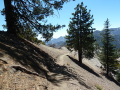
The Pacific Crest Trail, just before heading off to the ridge
A Hundred Peaks - page 13
The appealing start to the hike to Bare Mountain
Chaparral Mallow
(Malacothamnus fasciculatus)
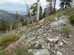
Sunday July 7, 2013. Bare Mountain seemed like a good idea - quite short and not too far from home. There was also the possibility of a second peak if it went well. The hike starts out on the Pacific Crest Trail, so it is nice and easy to find. The warning sign seems a little over-blown. Yes, the area had been burned, but flash floods were not in the forecast. The trail was probably in worse shape a couple of years ago, when the fire was more recent. Anyway, there is a use trail a short distance up the PCT, crossing a gully and heading up a ridge. It is very faint in places, but I had entered a few waypoint coordinates into my GPS , so I was able to get a sense of how to make my way up the rather steep slope. It was about 40 minutes, all up, to what is referred to, imaginatively, as "Bump 6168."
From Bump 6168 it is all either up or down, with up being the dominant, until reaching a firebreak on the main ridge leading up to Bare Mountain peak. Fortunately, there is a nice Forest Service marker pole right where the use trail meets the fire break, so turn left and keep on up, with occasional down stretches. The changes in elevation are quite steep, and after a long break from hiking in this kind of terrain, they were tiring. And, despite a mild forecast, it was getting quite warm. But, I made the peak by 11:50, two hours after setting off. It was only 2.7 miles, but with 1760 ft of elevation gain and 740 ft of loss.
After a few minutes on top, I set off back down, making it down the ridge fairly quickly and then going completely loopy. I blame the heat. I saw the Forest Service marker but decided that didn't look right and I needed to go to the next bump on the ridge before heading down. Even though it was not in the least bit familiar, I managed to think I must be righht until I ended up in a rock field from which there was no safe way down. I backtracked to the marker and went down the correct way, having added 0.7 miles and 220 ft down and up to the hike. I was addled. By the time I made it back to the car, I decided it wasn't wise to try for another peak, so I ran away, to climb another day.
Friday July 12, 2013. Ready to get back up into the hills. The target this day was Copter Ridge, a fairly simple hike following a ridge down from Mt Hawkins, which I had hiked back in August 2011 as part of a four-peak hike along the Pacific Crest Trail, and then been near in June 2012 on a two-peak day. So I knew the first part, along the PCT, pretty well. It was a perfect day for hiking, having lost the heatwave of the previous weekend, and it's always fun hiking the PCT, because it is so low-stress. I can actually look around at the views, the birds, the plants, without having to worry about finding the trail.. Even I can follow the PCT without too much trouble.
View south from Windy Gap on the PCT
Alpine Sulfur-flowered Buckwheat
(Eriogonum umbellatum var. minus)
Wright's Buckwheat
(Eriogonum wrightii
var. subscaposum)
The top of Mt Hawkins is a short spur off the PCT, and the Copter Ridge leads south from the peak. Being a ridge, it's hard not to follow the correct route, because to fail to do would lead to rolling down the hill into one valley or the other. I like ridge walking, when there's just one ridge. Also, Copter Ridge is particularly lovely. It has some steepish bits, almost all down on the way out, so I didn't get too cocky, knowing I had to hike back up again, but it was a truly pleasant hike. It's about 4-1/2 miles there, of which almost 2-1/2 are on the PCT.
Copter Ridge - the ridge going back up to Mt Hawkins
Bush Chinquapin (Chrysolepis sempervirens), which was all over the slopes along the PCT
Back to the car after 5 hours, following a leisurely round-trip hike, with great walking, great views, and lots of cool plants, of 8.7 miles. Very nice.
Saturday August 10, 2013. Another good weather forecast - not too hot - and time for the last peak-hike before school starts. I drove out to Wrightwood and then headed back towards the west along the Angeles Crest. I was a little worried as I got close to Wrightwood, because there was a pretty impressive plume of smoke coming from a wildfire, but fortunately for me, it was east of where I was wanting to hike. I don't think it did much damage, so I don't feel bad about feeling fortunate. The first hike of the day was Pinyon Ridge. The instructions say to park outside a YMCA camp and climb up a ridge alongside it (it's private) to get to the trail. Well, while I was getting my boots on, some very nice kids from the camp, counsellors presumably, came over and started chatting and invited me to walk through the camp to the trail, and they would escort me. This, I'm sure, is because they didn't want some old weirdo skulking around outside the camp - safer to keep me in their sights.
After they had been so nice, I didn't have the heart to tell them I was now at the start of the wrong trail, so I hiked up it a bit - it ran alongside a streambed - and then tried to scale the slope opposite, at the top of which was the trail I wanted. Bad idea. The slope was very steep and very unstable. After scrambling part way up a gully, the rock I grabbed onto above my head, to pull myself up a large step, came loose. I was able to hold it in place while I stepped to the side, but I decided it wasn't smart to keep trying. I tried another part of the slope, but it was just loose dirt and I couldn't make any headway. So, I figured, what's the worst that could happen? If I followed the streambed up, I would be bound to meet the dirt road that the correct trail leads to, but, if not, I could just follow the trail back down and try to find the ridge I was supposed to take in the first place. In fact, after a very pleasant, and short, stroll along the trail, followed by hiking up the actual bed after the trail wandered off the wrong way at a stream intersection, brought me to the dirt road, less than half a mile from where the right trail would have taken me. My way was probably easier hiking, too. Up the dirt road was a doddle, and the top of Pinyon Ridge was easily reached.


The dirt road to the Pinyon Ridge
The view from Pinyon Ridge
The way back down was just a repeat - the trail I was supposed to take was no more obvious from the top than the bottom, and I was able to thank the kids at the camp as I left. Next, it was along the Angeles Crest and a cheese-and-Branston sandwich before attacking Mt Williamson. The first part of this hike is, again, on the PCT, then a use trail up a ridge to the summit. And, once again, the walk along the PCT was great. It's all up, but it's contoured and switchbacked the way a long-distance trail should be.
Views along the Pacific Crest Trail
The intersection with the use trail up the ridge has a cairn, and some kind soul has painted arrows on the PCT so through-hikers wouldn't be tempted to take the use trail - it's that good a trail. All that, and perfect weather too. Spectacular views, and the ridge was not too badly up-and-down, in fact it was very well-mannered. There is a false peak about 1/4 mile before the true top, and shortly after that there was what appeared to be a gendarme, but users over the years had made a trail down the slope and around it. Ease of navigation at its finest. A perfect 4 mile round-trip, totalling about 8 miles for the day. Now, back to work.
The intersection with the PCT