A Hundred Peaks - page 5
Back to the San Gabriels
With the summer drawing to a close, I have less time to head for more-distant peaks, so back to the San Gabriels. Actually, I really like the San Gabriels, and to have these mountains on the doorstep, for when I just have a day or so to spend walking, is wonderful. So, not a come-down, far from it.
Saturday August 15 saw Brynne and me in the mountains near the Mt Waterman ski area. This is the first time Brynne (or anyone) had accompanied me. Given that she prefers studying nature when she walks, I wondered how good an idea it was, when I get my obsessive-compulsive "I have to get to the top" bit between my teeth. Anyway, Brynne didn't summit any of the peaks, just being content to walk.
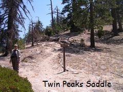
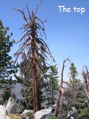
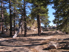
The walk up from the parking area on the Angeles Crest was very pleasant, winding its way gently up in a nice patch of pine forest, coming to a trail junction after about an hour. There is a short (3/4 mile) trail up to Waterman Mountain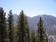 , or a longer and considerably more topographically challenging trail to Twin Peaks, visible across the valley. So, of course, we went to Twin Peaks. It's a fairly steady descent down the north side of Waterman as far as Twin Peaks Saddle, then around and partially over a knoll to another saddle and then straight up. Someone had the decency to start the use trail with a modicum of zigging and zagging, but they then abandoned all pretense, and one goes straight up, on loose decomposed granite. It's quite a slog. It was at some point here that Brynne lost interest. I didn't actually enjoy that bit too much, but I did stick with it to the top, surprised to find two people already up there. They were not doing this as part of the Hundred Peaks, so they really had no excuse. It was a nice view from the top, admittedly.
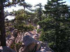
So, of course, having gone up it, no choice but to go down. That was quite a strain on the knees, but accomplished safely. I did remember to collect Brynne en route, and we set back up from the saddle to Waterman. That is just a long, slow, climb up, so I pressed on ahead, giving me time to go up to the top of Waterman while Brynne dawdled. So, of course, having gone up it, no choice but to go down. That was quite a strain on the knees, but accomplished safely. I did remember to collect Brynne en route, and we set back up from the saddle to Waterman. That is just a long, slow, climb up, so I pressed on ahead, giving me time to go up to the top of Waterman while Brynne dawdled. The walk up to the top of Waterman was delightful - a gentle slope, well wooded, and cool. The summit itself didn't disappoint, though it wasn't instantly obvious which was the highest point. After a bit of seemingly aimless wandering, I found the highest outcrop (though no register).
It was all downhill from there, arriving back at the car quite tired in the legs. We stopped at Newcombs Ranch, the biker bar on the Angeles Crest Highway (most of the bikers who go there seem to be Harley-riding bankers in their mid 60s, so that's not as dangerous
as it sounds). The hamburgers were not what one would travel hours for, but the Sierra Nevada Pale was very welcome. Twin Peaks, incidentally was peak number 25.
One last day before the semester starts. The following Wednesday, I was back in the same area. Winston Peak and Winston Ridge were the first targets of the day, starting off from Cloudburst Summit, and that was a good choice. This was quite different from the slog up Twin Peaks, being a fairly gentle uphill most of the way. Coming down the north side of Winston Peak was quite steep, but was not uncomfortable. The soft dirt was so deep that most of the way there was no stress on the knees. It was a lovely day, not too hot, good visibility (it's nice to be able to see the next target when taking an unknown use trail), and very pretty pine forest. This section of the San Gabriels is quite different from the west end (Josephine, Strawberry and so on) because this is not chaparral, instead being pine with some oak woodland. It was quite breezy up there, and the wind sighing in the pines was a high spot of the experience. On the way back form Winston Ridge, I took a slightly different route to avoid going back up the steep north side of Winston Peak, a route that quickly picks up the Pacific Crest Trail. The more I see of this trail the more enamoured of it I become. One day.


Winston Peak _______Winston Ridge: at the top _________________Two views to west and north
As it was only 1 pm, there was plenty of time for Mount Akawie, the trailhead for which was only about half a mile further east along the road. Another super hike, cool, breezy, and pine-covered. Paradoxically, it was unfortunately short. Walking in conditions like this, I'd be happy going all day. But, it was less than a mile round trip, so even allowing for lunch at the summit, I was still back within 45 minutes. So, that meant going further along the Highway to Dawson Saddle, the trailhead for Mount Lewis. For some reason, right on the road there it was uncomfortably hot, and the trail up to Lewis (another sub-one-mile trip) looked uncomfortably steep. Once on the trail, under the trees, I was wrong about the heat. I nailed the uncomfortably steep bit, though. It was insane. The average slope was 23 %. Average. Given it was traversing a slope that disappeared down into nothingness (well, it seemed that way), this was definitely the most challenging of the day's hikes. It was worth it, though, very nice on the top, and coming back down was nothing like as hairy as I had imagined it would be. That always seems to be the case.


___________ The trail up Mount Lewis ___________________ Nice at the top _________ and happy to be there


The end of the summer vacation. I will try to get some days during Fall to keep this up. Even with the unexpected tiredness of my legs going up some of the steeper ones, I'm really enjoying this.
-------------------------------------------------------------------------------
And that's when I lost momentum. Between then and January 2011 I completed one peak, Sunset. It was nice in that I hiked it with Brynne, but it was otherwise somewhat unremarkable. About 7 miles round trip, most of it on a fire road. However, it was nice to hike in a bit of snow, and we found a Coast Horned Lizard, which was fun. The view from the top was great as well. So, although not a challenging hike, a very nice day of naturalizing.


Not surprising that you don't see many of these. View of Baldy (Mt. San Antonio)


