
The last weekend before the end of the semester, and I needed a break from grading finals and writing reports. So a hike was in order.
I thought I should continue to branch out through the San Fernando Valley and beyond, so, even though I didn't relish the drive, I decided to head out to the Liebre Range, north of Santa Clarita, between the Antelope Valley to the east and the Los Padres National Forest to the west. I set off at about 7:20 on Sunday, May 22, 2011, and, finding no traffic at all, I exited I-5 at Castaic after only an hour. The drive northeast along Lake Hughes Road is spectacularly beautiful - a cottonwood-lined stream running along a gorge covered in really nice chapparal. It's actually a sequence of canyons, but either way the result is a delightful drive. At Lake Hughes, it's a short drive to a Forest Service road into the mountains. A good road, but I had been warned by a ranger earlier in the year that it's not good when wet, which it was then. I can believe it, but in the dry it was a great road.
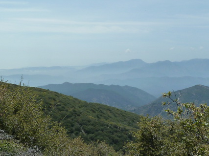
The first peak of the day was the aptly named Sawtooth Mountain. I set off from the trailhead at 9:43 and immediately started my descent towards the peak. The peak is actually 150 ft below the trailhead, but the trail has a total of 1700' gain in a 4-mile round trip. It is all either up or down, and quite a lot of it is steeply so. It has the nice feature of being on a fire break the whole way, so even I couldn't get lost.


Down to the peak! That's looking down into a saddle And that's on the hike back up
One nice thing about the day was the number of flowers. The chaparral does not have the huge showy displays of the desert in bloom, or of alpine meadows, or the prairies, but looking close, there are some real beauties.


Chaparral Pea California Suncup Monkeyflower, sp
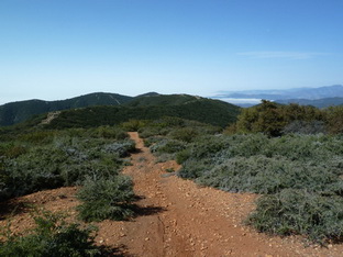
Well, it was a tiring up and down the whole way, but very enjoyable. I got back to the car at 12:09 and had a gourmet lunch of beef jerky, mixed nuts and craisins. Yum. That is what I eat on every hike (with occasional variety such as turkey jerky or real raisins, but that's about it). It seems to me it has a balance of protein, fat, salt, and sugars, and I can't face anything more substantial when I'm walking. Some Kendal mint cake would round it out, but I have no idea where to find that around here. After lunch, a short drive back along the dirt road to the trailhead for Burnt Peak. This is even easier navigation than Sawtooth. Well, it couldn't be easier, but it was no more difficult. The trail is an access road to communications equipment on the peak, and it is in better shape than the dirt road leading to it, because it is almost never used. So, I had to keep forgetting I was walking on a dirt road, which was, in places, relatively easy. Again, there were some lovely flowers (and other things) for those who were looking.

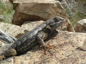
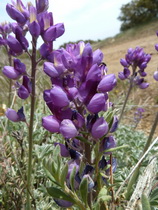

Western Wallflower A magnificent Western Fence Lizard Lupine, sp Some Asteraceae or other

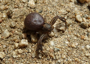

Miners Lettuce A crab spider I think this is a species of Geranium
For some of the way, the road went through a nice gallery oak forest, which is where the miners lettuce and the mystery white flower were. Up at the top it was quite open (I guess they like their communication towers free of surrounding vegetation), but that was where I saw the wallflowers and that very handsome fence lizard, so even that had its consolations. I got back to the car at 15:15, taking 2:25 for the close to 6 mile round trip. Not exactly a fast walk, even though there was minimal topography along the road, but it was a lovely day out.
Next up - Mt McDill ( June 19) and Liebre Mountain with Brynne (June 26).
![]()
![]()
![]()
![]()
![]()