A New Year, a New Set of Mountains
January 2012 in Joshua Tree National Park. Brynne and I decided to get a change of scenery before the semester begins, and we hadn't been to Joshua Tree for a while, so that seemed like a plan. Plus, it hosts a number of peaks, so I could get the year started well. Turns out it was a really good decision - a great trip.
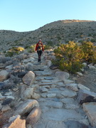
We went out there on Thursday January 12, leaving after the morning traffic, and we made it out there very quickly - 65 mph the whole way. Since it was a holiday weekend coming up, we snagged our campite first of all (a good idea, because the campgrounds were full by that evening), at Ryan Campground, on the north side of the park. This site is heavily used by rock climbers, more of which later. But even with all that, we were on our first trail, Ryan Mountain, by 2:40. This is a short hike, a little under 1.5 miles each way, but with a respectable 1200 ft of gain (1060 ft net), a 14% average grade.
Starting up Ryan Mtn,
looking back
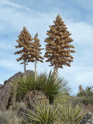
Mojave Yucca,
near the top
We were at the top within an hour - a nice gentle pace, since we didn't want to do anything too strenuous the first day.
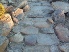
And the trip back down was also slow, because we were guarding our aging knees. The trail is a good one, with wonderful views over the Mojave and typical desert mountain vegetation, at least for this desert, including Mojave Yucca, which seems to replace the Joshua Tree at this elevation. It's a popular trail - we saw several folks heading up as were coming back down close to sunset (which is very early this time of year at this longitude - it's close to the eastern bouindary of the time zone, and it was dark by 5:00 pm every day). In its lower reaches, it is eerily reminiscent of the Inca Trail.
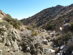
The lower reaches of the Ryan Mountain Trail
The next day was, of course, Friday 13th. A great day for me to go wandering off alone cross-country, and for Brynne to take the Honda down narrow dirt roads miles from anywhere, looking at geology. So that's what we did. But first, the campground. Rock climbing looks like a nice pastime - you more or less alone against gravity, pitting your decision-making skills and physical prowess against an unforgiving rock face. So why are so many rock climbers such pricks? Those camped at the Ryan Campground while we were there, anyway, felt that no-one there had any desire more pressing than to listen to them talking loud and late about what awesome rock climbers they are. One pair, in particular, at the campsite next to us. Well, pair is an exaggeration, because one of them never got a word in against his tent buddy, who was the most loud-mouthed, foul-mouthed, douchebag I have ever had the misfortune to encounter. Yes, Site 19 on Jan 12th/13th, I'm talking to you. Being a kid is no excuse. Of course, you will never read this, but you should gain a little respect for women, your parents, and your campsite neighbors, in that order. Otherwise, someone larger than I and less concerned about staying warm in his tent will rearrange your face. End of diatribe.
Fortunately, there are few things as powerful for resetting one's attitude than a really good walk in the country. And this day provided that. It was nice being camped in one place for three nights, rather than striking camp each night, because we could get up, have coffee and breakfast, and still get out and about at a decent time. We had a scenic drive over to the designated drop-off point, down a dirt road, and I was walking by about 10 after 10. Bernard Peak and Little Berdoo Peak make for a nice loop hike. No trail, but wide open country so I could see where I was going, and low and sparse desert vegetation, so I could get there. Very different from cross-country bushwacking in the chaparral, which way madness lies.
Heading towards Bernard Peak, the point on the horizon right of center. Little Berdoo is the third peak from the left.
Looking back down to the road. It's more or less straight up for the first half hour.
On the way up. This looked like marble, but Brynne tells me it's a type of quartz.
Close to where I took the first photo, I was surprised to see someone looking at me from one of the rock outcrops that lay along the ledge. He had on a light tan jacket, but that was all I noticed before he disappeared. I thought it odd that he would be heading towards me, since the obvious way to do the peak was the way I was going, unless he had done the reverse of the loop I was on - in which case he had made a very early start. Only after hiking some more distance and not seeing anyone did I realize that he was, in fact, a desert bighorn sheep. Scale can be deceptive in these desert mountains - the air is so clear objects look closer than they are. The day before, Brynne and I had seen a vulture perched on top of one of the high rocks, and it turned out to be a ruddy-faced climber in a black jacket.
Heading up Bernard Peak, looking back
Looking back along the ridge from Bernard Peak
Looking ahead to Little Berdoo (about in the middle of the photo)
Made the summit of Bernard peak by 11:40, so an hour and a half to do a little over 2 miles. In fairness, there was a lot of up (1330 ft), and a fair amount of picking my way around all the little lumps along the ridge. Fortunately, no gendarmes, though. The walk across to Little Berdoo was great, following the watershed (in the English sense, as in a roofline) around the head of a wash. Only about 160 ft elevation loss, which was nice, then 210 ft gain. Very civilized. It was a glorious day, about 60 degrees, breezy, and crystal clear.
Heading across the top of the wash
View from Little Berdoo Peak
Long view from Little Berdoo Peak
From the top of Little Berdoo, a short backtrack to the head of the wash, then down into the wash itself, and an easy, fast hike back to the road. I'm generally a little nervous about walking down watercourses - today there was no danger of rain, but I always like to know that I won't end up at a high rock face. This wash was particularly nice because there was no high rock face (only two places where I had to lower myself down a rock at all) and the sides were relatively easy in case I did have to climb around. No intimidating canyons. I was so excited, in fact, I stayed in the wash too long and missed my exit point to cut back to the car, so I added about half a mile of walking back up a dirt road to the hike. But that was fine. I averaged 2.5 mph from the peak to the road, which for me nowadays is a good pace.
The upper reaches of the wash
And then like walking on a cushioned roadway
A sheep that didn't make it
An antelope ground squirrel that thought it would get some of my lunch, but didn't.
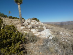
The next day, after a good night's sleep (the obnoxious jerk having left), Brynne and I headed up to Lost Horse Mine, a popular destination from which it is a short climb up to Lost Horse Mountain. Another wonderful walk on a really good trail, as befits a popular destination. Apart from the fact that there were a lot of yucca and juniper, it reminded me a lot of hiking in northern England - rolling country and a nice stiff breeze and cold-ish temperature. There was a freshness in the air that I don't often experience in hiking southern California, and I really was reminded of the moors. Except for the yucca, especially. This was the first time we had seen Parry's Nolina being dominant. It's quite different from the Mojave Yucca.
Brynne near the start of the Lost Horse Mine Trail
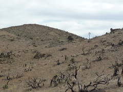
Burned area - this ecosystem is not fire-adapted, unlike chaparral
The Lost Horse Mine, fenced to keep out vandals, sadly
From the mine, we walked a short distance along the loop trail until we saw a suitable place to leave the trail and head up the mountain, cross-country. Fortunately, there was a faint use trail right there, so while we didn't (couldn't) follow it precisely, we figured others had decided this was the best approach before us. It was only 12 minutes from the trail to the peak, which once again gave glorious views.
The summit of Lost Horse Mountain
View of Malapai Hill and the dry lake bed
Desert Mallow, the only live wildflower we saw the whole trip.
We were then off the mountain and back the way we came (we decided against completing the loop, which added 2 miles to the day, because we wanted to get in another hike), arriving back at the car at 1:30, having set off at 10:15. We spent a bit of time looking around the mine, which was well-spent.
From the trailhead it was a short drive to Keys View, the start point for our next (and last) peak, Mount Inspiration. Keys View is the highest drivable point in the park, and it is touted as that, but if you climb the hill behind it, going up towards Mt Inspiration, the views are absolutely magnificent - the Salton Sea, and three of the major mountain ranges of southern California, the Santa Rosas, San Jacintos, and San Bernadinos.
The view of Keys View, with the Salton Sea behind
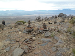
Some kind soul has done a good job of placing cairns along the path, which otherwise would be tricky to follow at times.
The view from Mt Inspiration. Truly inspirational.
Fire all the way up here, too
After the initial slog straight up, overlooking Keys View, the route to the peak runs along a ridge, topping or skirting a number of false peaks. On some of the rockier stretches we really did appreciate the cairns - saved us quite a time in trying to find the route through. One thing that was odd was a small hut or shed in one the saddles, painted a very odd pinkish camo scheme, which apparently housed instruments of some kind. There were two sighting holes facing (roughly) Keys View, and I wonder if one of them was used for tracking Bighorn Sheep - there would have been a nice view of a ridge from there. What it looks like from a distance is a porta-potty, and at first I thought it might be there in case one was inspired by the view. But no, just some government stuff.